

Explore
Dengue risk forecasting, and what to do about it.
Flyttr Dengue combines predictive modeling with prescriptive, actionable insights inside an intuitive, map-based interface, covering over 5,000 Brazilian cities down to neighborhood and building level.
Hyper-local dengue risk intelligence
Pinpoint dengue hotspots down to neighborhood or building level for targeted interventions.
Dengue scenario simulation
Test what-if strategies before deploying resources: optimize cost and impact.
Dynamic dengue forecasting
Plan weeks ahead with confidence using continuously updated predictions.
On-demand dengue insights
Query the AI assistant for instant answers, generate reports, and visualize risk in interactive maps.
Identifying target neighbourhood blocks in the platform: eight-week city forecasts, selectable epidemiology and environment layers, and city detail on click.
01
AI-powered decision-making
Flyttr Dengue delivers cutting-edge dengue risk forecasting by integrating two advanced modeling approaches.
One model uses macro-data and trends to deliver city-wide predictions for Brazil, offering reliable insights weeks in advance to support proactive planning. The second leverages satellite imagery and geo-spatial analytics to pinpoint mosquito risk at the neighborhood and even individual building level, enabling highly targeted interventions.
Both models are validated through robust performance metrics (confusion matrices, mean errors, area under the curve, and correlation matrices), ensuring the forecasts are accurate and trustworthy.
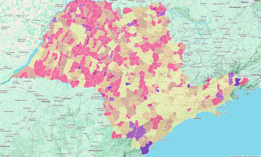
Dengue risk predicted 4–12 weeks in advance, based on the latest available data for each city. Clicking a city opens building-level predictions.

Heatmap showing estimated mosquito risk at neighborhood and building level.
Simulate two extra spraying rounds in the north zone next month.
Running the scenario now. I will compare forecast risk with and without the rounds, and summarise the cost and impact trade-off.
Ask, generate a report, or simulate a scenario→
02
Flyttr Dengue AI assistant
The assistant harnesses real-time dengue data and community insights to deliver smart, actionable intervention strategies. With a natural language interface, users can query risk levels, generate reports, and simulate tailored scenarios for any location.
Built on a multi-model architecture featuring advanced large language models, it breaks complex objectives into practical steps, with memory management and tool use to interact with APIs, data sources and enterprise workflows. Connecting technical tools, data sources and expert human oversight is what keeps the output trustworthy.
03
Dengue forecasts with unmatched precision
Flyttr Dengue predicts city-wide dengue risk up to 12 weeks ahead using a model trained on over two million data points. A separate 12-month outlook extends the view further out at lower accuracy, for budget, procurement and seasonal planning cycles. By continuously updating with the latest local data, the system delivers highly accurate forecasts for more than 5,000 Brazilian cities, empowering proactive public health action.
The model analyzes how data evolve over time, identifying patterns and relationships between past and present events, so factors such as climate, case history and population dynamics can be read as influences on future risk. It was developed to handle complex scenarios where data show irregular variation or non-linear patterns, and it maintains reliable forecasts even when the available data are heterogeneous or incomplete.
04
How the forecasts are calculated
Flyttr Dengue harnesses extensive data from meteorological, socio-economic and epidemiological sources to train a robust machine learning forecasting engine, combined with satellite and environmental datasets at a range of spatial resolutions and update frequencies.
Recognizing that update schedules vary across municipalities, an automated integration process continuously incorporates the most recent information available for each city (temperature, precipitation, incidence trends and population indicators), keeping risk forecasts aligned with the most current information for each municipality.
05
How Flyttr Dengue stacks up against other dengue forecasting and nowcasting tools
Unlike conventional tools limited to reactive dashboards and coarser geographical scales, Flyttr Dengue integrates diverse datasets and extends forecasting up to 12 weeks, enabling earlier and more targeted interventions.
Value proposition
Flyttr Dengue
Current tools
Coverage
Varies, mostly state- and municipal-level only
User interface
Analytical and dashboard-style layout
Data sources
Epidemiological, climate, social media data. Updated weekly
Granularity
City or state level only
Forecast horizon
Mostly nowcasting only, not forecasting
AI power
Forecasts only. Natural language interaction not available
Prescriptive analytics
Not available
Human touch
Not available
06
How Flyttr Dengue can help you: select case studies
Case study 1
City health authority
Flyttr Dengue can help metropolitan health departments by enabling the early identification of potential dengue hotspots, often up to two weeks before spikes in cases. With these insights, teams can reallocate spraying resources and enhance community outreach in targeted zones, supporting efforts to reduce dengue incidence compared with previous seasons.
Case study 2
Private sector partnership
Hyper-local forecasts can support companies to better protect their workforce and serve their customers. With timely information, organizations are better equipped to adjust delivery routes and implement preventive measures in high-risk areas, reducing absenteeism and strengthening operational resilience.
Case study 3
National policy planning
At a national level, health ministries may integrate Flyttr Dengue into disease surveillance systems to access extended forecasts. Such integration can help optimize the allocation of vaccines and vector control budgets, contributing to enhanced national preparedness and long-term resilience.

Ready to act?